We are now in Winton for a few days. We had previously visited the Waltzing Matilda Centre, a beautiful museum in this outback town.
Sadly the building had burned to the ground in June 2015. The new building is under construction & should be ready for a grand opening in April 2018.
We wanted to visit the Dinosaur Stampede exhibition at Lark Quarry. Hubby thought we should take in a day tour to do it is style for a change, so this is our transport for the day.
Owned & operated by a young lady, she was a great tour guide.

Lark Quarry is 110km south of Winton & we visit the Merton Gorge en route. We have morning tea on the mesa with fabulous views for as far as the eye could see. There are several mesa's in the region.
Looking eastwards.

I can't believe that plants can grow up on this rocky environment

Looking westwards.


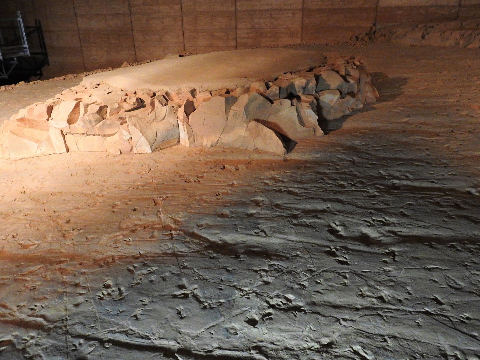
The purpose built building has been built over the carefully excavated stampede footprints.
Panicked dinosaurs left more than 4,00 muddy footprints on the shores of a lake.
The dinosaur trackways are protected inside of solar-powered shelter.


There are several sized footprints in amongst this small area of excavation.
You can see the sections that have been preserved & left un touched.

There are approximately 3,300 footprints of the world's only know dinosaur stampede that occurred 100 million years ago on the muddy shores of a prehistoric lake & now preserved in rock.


There are a couple of walking trails around the Conservation Park. As you can see, the area consists of a lot of spinifex grass.....homes for tiny elusive birds.


From Winton we head into Bladensburg NP. This 84,900ha NP was declared a National Park in 1984. It is on the northern area of the Channel Country & has impressive flat-topped plateaus & residual sandstone ranges that provide a scenic backdrop to vast grassland plains, river flats, river red gums & rocky scarp. There are also dinosaur fossils found here.
We base ourselves for 2 nights at Bough Shed Campground right beside Surprise Creek.
The drive from Winton is approx 25 kms.

Red kangaroos were common in this region. The Reds are the male & Blues are females....I think this was a young male.

Skull Hole was the site of an aboriginal massacre in the late 1800's prior to white settlement on Bladensburg.

Spinifex clumps were a common sight around this district. But a great portion of Bladensburg was Mitchell grass country.

Many flowering Western Bloodwoods were dotted throughout the NP & were attracting the honeyeaters.

I believe this is a Black Wallaroo. They are a different shape to the more common Grey's & Red Kangaroo.

Bladensburg was a sheep station prior to it becoming a national park.
The Mitchell grass plains were great provision of food for the enormous numbers of sheep in good seasons.
We took a 40km return drive through out part of the NP. It starts at the homestead, leads over black soil plains, through grassland & channels. then climbs up the jump-up to Scrammy Gorge & Lookout further on.
This is a circuit for high clearance 4x4 only.
The shearing shed.

I mentioned above that there was an enormous number of sheep in good seasons......look at the fact sheet, remembering that this was only 84,900 ha in size. It appears that the seasons were terrific in the 1920's with 600,000 sheep & by the 1950's were times of severe drought.

I'm not really sure how just 6 shearing stands coped with the sheer number of sheep in the 1920's.
They'd be shearing for months on end.

The old wool press where wool is stamped in by foot into the bottom & top containers before joining them together.


The shearers quarters were situated right next to the shearing shed, but it appears most of it has been destroyed....possibly by fire.

We then drive up onto a jump up which became a huge rocky plateau.
We decided to drive to the further most point & look at the attractions as we drove back.
Scrammy Lookout.....high lookout looking over the grassy plains below.


As we drove around this circuit of the NP, I was amazed with the bonsia'd Ghost gum trees.
The earth with which the roots have to grow in is particularly hard & a significant amount of rock.
I can only imagine the age of some of these trees....perhaps more than 100 yrs old.

This 1 of aptly named Octopus Ghost Gum.


As we drove the Scrammy Drive we were intrigued by the places that were named after Scrammy.
It seems that Scrammy Jack was a boundary rider. He was working for neighbouring property called Vindex Station, but was found drowned in a waterhole on Bladensburg 1893. The grave stone has been reconstructed by locals historians.

This is Scrammy Rock hole.....it didn't look that deep.....but it's actually 2m deep & rarely dries out.


We made it back to the start...the Bladensburg Homestead. The building was transported to the site some time in the 1910's. It now houses the park's visitor information centre.
I saw the aerials on the roof & decided to turn my phone on. Very surprisingly we had internet & phone service. After looking at the buildings, I sat down on the steps of the homestead & quickly checked emails & uploaded a few bird watching lists.

This building is a "Meat House"......the carcass of an animal....usually beef, sheep or pork is hung up overnight & then butchered into cuts the next morning.

Staff quarters.

R & R to mostly chill out in the heat.
Hubby had a game of golf whilst I went birding.
Before we left town, we made the obligatory visit to empty our toilet cassette......this 1 was a little novel from the normal.

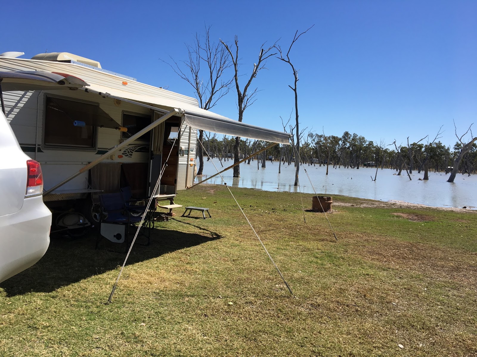
Our next stay was on a private property which was a wetland.
28kms SW of Barcaldine is Lara Station, approximately 13 kms by a well graded dirt road from the highway. Lara Wetland is a bore water fed shallow lake that is home to hundreds of birdlife.
Their website says to "enjoy your stay in 1 of their tranquil shady camping spots" next to the lake...........we needed a sunny spot with no trees that would throw shade on our caravan rooftop solar panels...hence our very sunny spot......we always need sunny spots....but what a view....the waters edge is just 10m from the back of the van.....
& we had green grass under our feet....for the 1st time in 6 wks, it was heaven.
Sunset over the wetland

Sunrise

There were on site amenities blocks to use included in our $10 per day fee....cheap as chips.
There was also a thermal controlled Artesian Mineral Hot Pool

Upon exiting we again made a deposit to this novel idea for a dump point.


Hubby was quite keen on checking out the Wool Scourer. There used to be 100's of these buildings throughout Australia. Sadly they all closed up & most were sold off as scrap metal.
Blackall has the only fully intact steam-powered wool washing plant left in Australia.
The Woolscour operated under steam power from 1908 to 1978. Thanks to the Blackall community the plant was brought back to it's former glory from 2002 & the machinery is as functional as it was then. The Woolscour is quite a tourist attraction for the town.

The bore water was an important component for the operations of the Woolscour.

Waiting for the tour to start, sitting next to a very old tractor.

It's hard to believe that in its infancy, shearing sheep went from hand held shears to motor powered shears. It's still a very hard way to shear sheep as another person was required to rotate the handle for the shears to operate.

That's the wood fired kiln to boil the water

The boiler that produced boiling water & steam.

All the machinery were well oiled machines....purring along under volunteers guidance.

This was also a working shearing shed. There were at least 20 shearing stands that was required to shear the hundreds of thousands of sheep from the Blackall district.

I think the sheep pens were made of gidgee wood.....extremely hard wearing.

Once the wool was shawn from the sheep, it was craftily thrown onto this slat table for the outside skirtings to be pulled off....the outside dirtier wool. The wool was classed by an expert wool classer to be graded into how fine the fibres were. They're the bins to the back.

The good wool was foot pushed into each 1/2 of this wool press & then joined where both sides were compressed even more to form a bale, like the 1 to the right.

The Wool scourer was there mostly to wash the dirty wool of the underbellies, head & backsides of the sheep.
The washed wool was then baled to be exported to be made into wool fabric.
These are the pulley's that operated the wool wash.

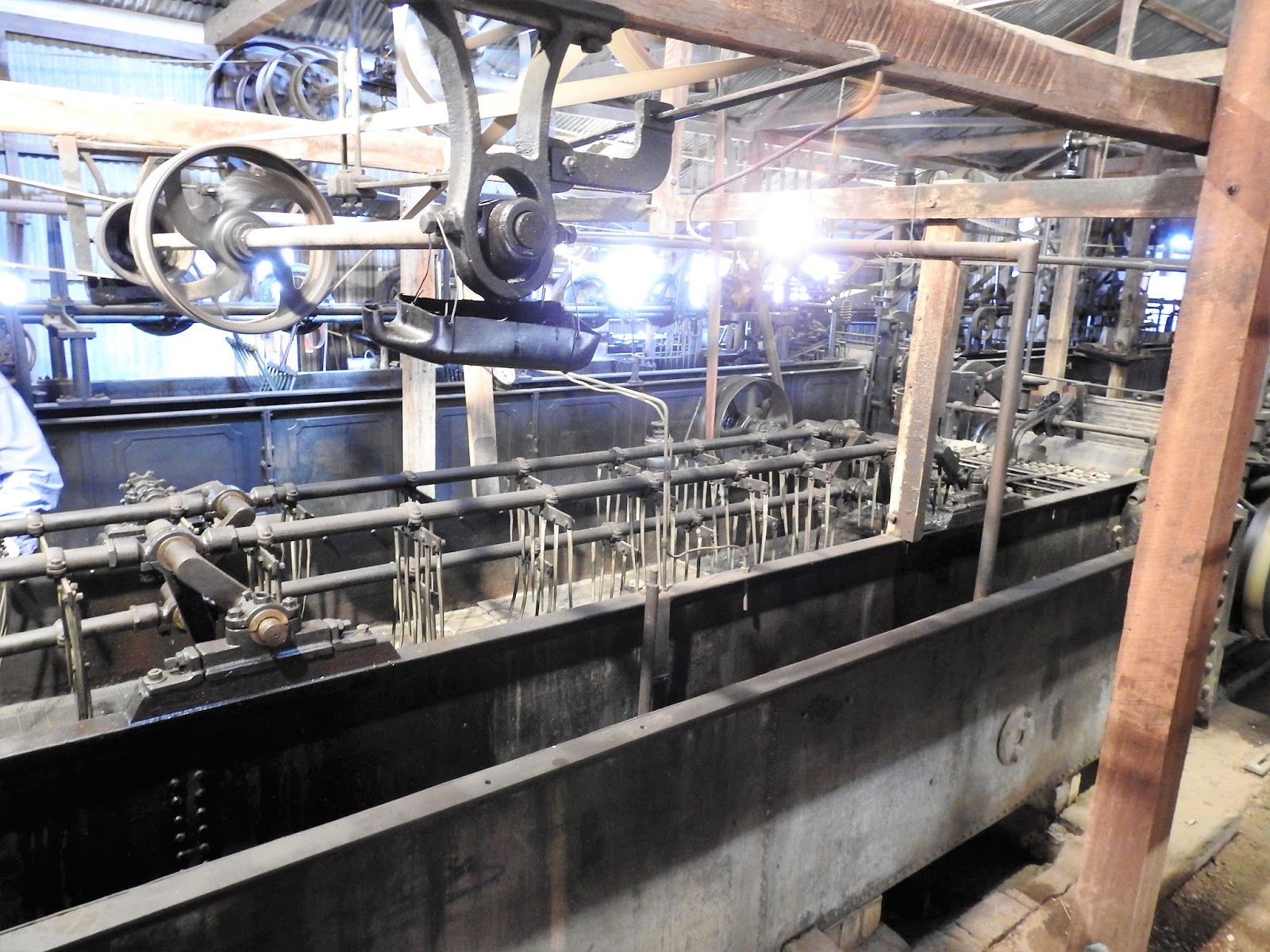
The saturated wool then had to have the water pressed out.

Before it was moved into this huge dryer.


I found this old 1935 Federal Truck at the back of the building.

There was a free camp down by the Barcoo River within walking distance of town.
We had dinner here as well.
"Clancy of the Overflow" is a poem written by Banjo Paterson around 1889.

We headed south towards Yaraka....another gravel road that was in very good condition.
Sadly the road gave us our very 1st tyre puncture in 6 yrs of travelling Australia. Even sadder was that the tyre was just 6mths old or < 10,000 kms of use. Thankfully the tyre could be repaired to be used as a spare.....there's also another spare on the roof of the car as we were in far western outback & remote Qld.

We arrive at Yaraka. Yaraka was enroute to Welford NP & Stonehenge.
What an amazing gem this tiny place it. We arrived around late morning & the publicans brother was sitting on the veranda with a coffee. He welcomed us with open arms & showed us around....the council run caravan park at the back would cost us $3 / night including power & water......& choose any site we want....once we've set up, he invited us to make ourselves at home in the hotel lounge & help ourselves to the free tea & coffee.
He also proceeded to tell us we're welcome to use the tennis court if we wanted a game of tennis, they'll lend us the rackets.
He also told us that there would be a sunset tour up to the nearby jump-up called Mt Slocom.....it was free with just a gold coin donation to RFDS. If we feel like having dinner at the pub, we could just place our order before we hop on the bus & dinner will be ready when we get back from the sunset tour.
This little town has a population of 12 people.
The local school closed down a few years earlier & the teacher / head mistress was out of a job, so she purchased the hotel. (She was on holiday when we were there, hence her brother was overseeing her pride & joy)

After lunch we checked out the Railway Station....the railway line from Blackall was completed in 1917. It was a vital link for the Yaraka region. Stock from the Channel Country were brought to Yaraka & loaded onto the trains for transportation to the Rockhampton Meat Works. Graziers wool clip was also transported to Rockhampton. Food supplies, mail & passengers come west to Yaraka.
Sadly the railway closed down in October 2005....it was "The End of the line" for this railway.....said with a double meaning....the railway line didn't go any further than Yaraka.


Near the railway station was this display of old machinery used by the pioneers of the area.

We hopped on the pubs mini bus to take us up to the sunset tour of Mt Slocom.
Mt Slocom is a jump-up 30 mins drive from Yaraka.
Wow...what a view we had. The colours were enhanced with the setting sun.


We stayed 2 nights at Yaraka. On the 2nd day there I went on an early morning walk past the towns dams. The water levels were quite low, but the birdlife were loving having the water supply.
I found this flower .....on a weed.


The moon was quite stunning in the crisp clear sky.

We did some exploring around the NP. Honeyeaters were attracted to the Eremophilia bushes that were flowering.

The desert drive was a 22km 1 way drive. Spinifex covered plains below the sand dunes.


We walked up on top of this permanent sand dune...trees & flowering bushes were some how thriving on top of the dune.


Further along we came to the Oil Bore. The Clay-lubricated drills bored 2,500 m deep for oil in 1986. Oil Bore now brings water from 1,800 m below the ground.

We also enjoyed the River drive & some of Mulga Drive which were both 4 WD access only.
I was looking for bird life & found the best birding was the Desert drive as there were several Western Bloodwoods in flower & the Honeyeaters & Woodswallows were loving the blossoms.
Next overnight stay was in Jundah.

Our next stop was at Stonehenge & we took a drive to the Rock Holes along the John Egan Drive.


At the back of our camp spot in the council run caravan park was this largish skink rustling in the leaf litter....minus the end of it's tail.

We heard from the local grocery shop owner that there would be a fresh food truck coming through town later that day. Wow....a refrigerated truck loaded to the roof with all varieties of fresh fruit & vegies.....this fellow drives north from Adelaide every fortnight with a load of fresh fruit & veg for the outback towns through Birdsville to Jundah, Stonehenge & further north.
> $40 spend was worth every dollar & our fridge was unexpectedly re stocked.

We also enjoyed another pub meal at the local hotel.
We were in Stonehenge for the Gymkhana & Rodeo out at the sports ground. Camping for the 2 day event was free.
We watched several dozen trucks arrive with any thing from 2 - 10 horses in the horse trailers.
There were hundreds of competitors from far & wide there for the event.

There were loads of events & too many to photograph


After the dusty w/e we headed south towards Windorah again.......we saw on our FB feed that our good friends Chris & Val were in the area & staying at a free camp not that far south of Stonehenge.....so we stopped for a night there too...... we had wonderful views from atop this jump-up / mesa.

Drinks in the afternoon

We stopped at Windorah for another night with Chris & Val & had dinner at the local pub.
Outback pubs have great hospitality & food & we tried to support them where we could.
We then set off towards Birdsville again.
Sculptures of the Dreamtime was on a hillside near Betoota. The Rainbow Serpent is formed by coloured rocks on the hillside to connect the 3 towns of Bedourie, Birdsville & Betoota.


We loved the diversity of the region.
From Birdsville we will head south on the Birdsville Track into South Australia to enjoy 3 months travel in that state......blogs of that state to follow sometime in the near future.
No comments:
Post a Comment