Most of our touring north of Bright was brown & quite dry, contrasting to the southern side of the Alps where it was lush green pastures for as far as the eye could see. It was such an amazingly stark contrast.
We stopped at Bruthen & the caravan park care taker was very accommodating in giving us a powered site for 2 nights despite all powered sites being booked out for the w/e as there was a vintage car festival in town for the w/e. It was amazing to have lush green grass under our feet for the 1st time since starting our trip.
The caretakers partner was an eccentric lady & the amenities block & camp kitchen were something that we've not seen before in a caravan park......photos below

That's the camp kitchen


Soaps, hand & body lotions, & other homely nick nacks in the ladies amenities


The next day we visited a little park called Fairy Dell Reserve.....I wanted to try find Superb Lyrebirds & other rainforest birds......I was rewarded with hearing & then seeing the Lyrebird.
The walk in the forest was wonderful with so much beauty & serenity.
I'm a big fan of the 100's of different fungi in rainforests seen on my walks, so bear with me as I post a lot of fungi :-)

Ther reserve is called Fairy Dell.....& some person has gone around the 1km walk trail placing little things related to fairies & little girls etc on green moss along the track


more fungi


From Bruthen, we travelled east through Orbost & then south to the lovely seaside town of Marlo.
We are in the East Gippsland area This was our 1st taste of the southern coast of Victoria & oh what a picture it was. There was plenty to explore around Marlo.
Cape Conran Coastal Park was just a short drive eastwards.
Cape Conran starts approx 20 kms east of Marlo & is only 11,700 ha in size, but it is packed with heathland & banksia woodlands.
The bird life here is abundant & I wasn't disappointed on my birding walks, & despite it being Autumn, many natives were still flowering.
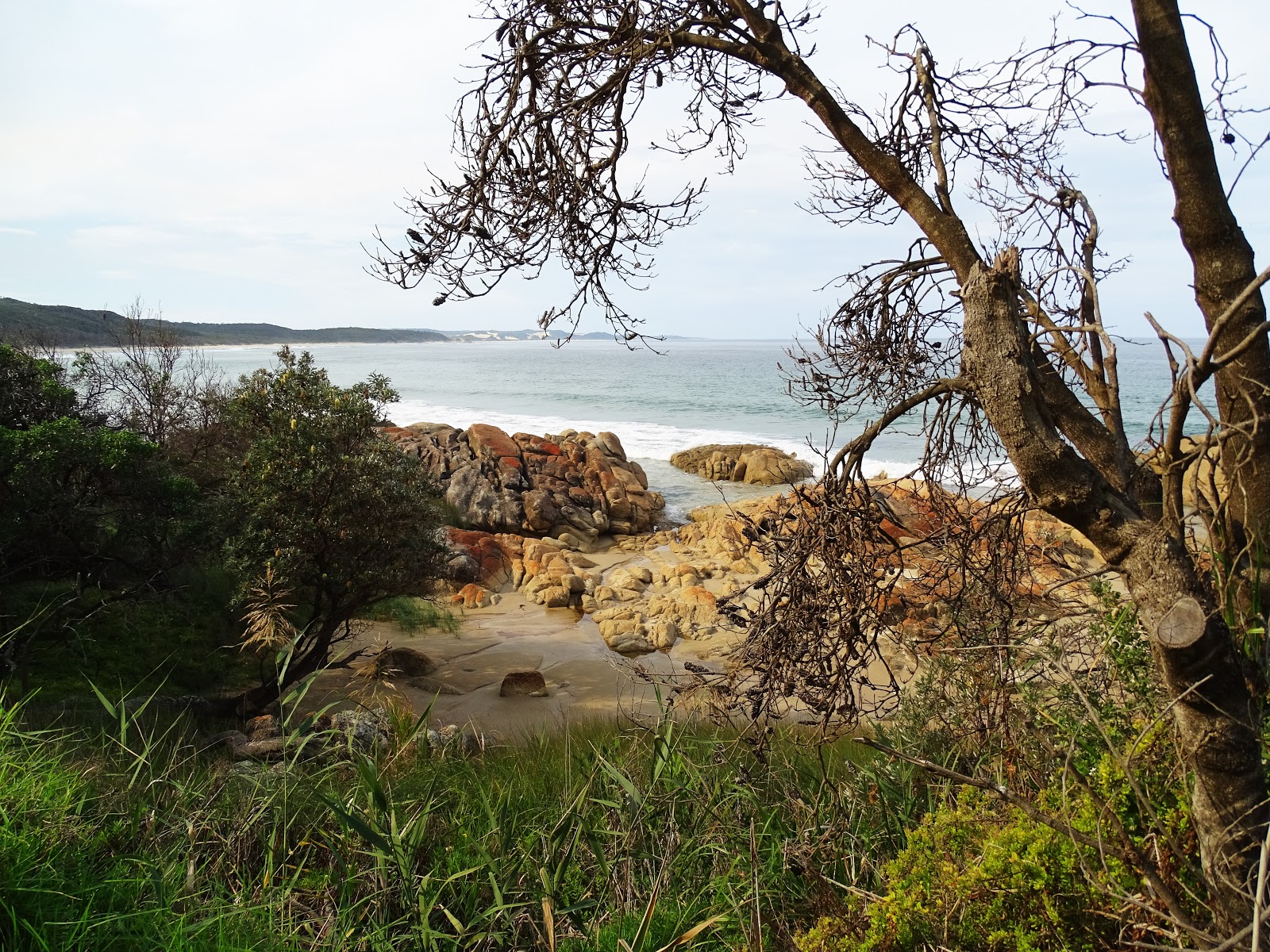
The coast is a mixture of sandy beaches & rugged rocks.

This is Salmon Rocks near Cape Conran in the Coastal Reserve.


1 of my bird walks was to a smaller nearby reserve called Cabbage Tree Creek Flora Reserve....so named for the Cabbage fan palm trees - Livistona australis - this the southern most strand of Cabbage palms remaining in Australia with it's nearest relative 180kms away in NSW. There are only 100 or so of these palms remaining in this reserve. The trail is flat & 1km in length displaying many other rainforest species as well& plenty of birdlife including the Superb Lyrebird where I had at least 2 or 3 singing away mimicking other bird calls.


Marlo sits next to the Snowy River mouth. The Snowy River is a major river in SE Australia & originates on the slopes of Mount Kosciuszko, Australia's highest mainland peak & runs 353 kms to it's mouth at Marlo via the Snowy Mountains of NSW, Alpine NP & Snowy River NP in Vic.
The water flow has been reduced since the mid 20th century to less than 1% after the construction of 4 large dams & many smaller diversion structures in it's headwaters in NSW as part of the Snowy Mountains Scheme.
The river was immortalised in cultural folklore through the poem "The Man from Snowy River" written by Banjo Paterson in 1890.

The Snowy River estuary near Marlo is a significant habitat for birds including migratory birds.
The 5km Estuary trail starts at Marlo & follows the escarpment in town before taking you through coastal forest to a magnificent lookout.

At the end of The Snowy River Estuary 5 km area is French's Narrow & saw similar views of the estuary, though some pools were deeper. Amongst the heath I found more fungi & flowering shrubs.


We ended up staying 6 days....we originally only booked 4 nights, but we extended it to 6 nights we loved the area so much. Rod did some fishing whilst I was out birding most days or joined me on some of the bush walks.
After our relaxing 6 days at Marlo we continued eastwards to Mallacoota. It is the eastern most town of Victoria & to get there along the Princess Hwy, one must drive (from Lakes Entrance) over 220kms through magnificent Gippsland eucalypt forests mixed with farming.
It is a very enjoyable drive. Much of Mallacoota's surrounding area is within the Croajingolong National Park.....pronounced Cro-a-jing-go-long....the name is derived from the local indigenous group given to the area.
Mallacoota is such a beautiful seaside destination that the population of around 970 grows to about 8,000 during Easter & Christmas time. Consequently, the council run caravan park is huge with over 600 sites with several amenities blocks dotted through out. I can imagine the traffic jams in this small town during holiday seasons, with some locals breathing a sigh of relief once the holiday makers leave. All the shops would have loved the extra business though.
The town is still very popular with grey nomad tourists though as a lot of them like to avoid large crowded places.
Again we initially booked 4 nights , but extended this by another 2 nights we were having such a wonderful time.
The weather was magnificent with temps in the mid to high 20's & relatively clear skies & the area had much to explore - short walks, long walks, short drives, long drives......and relaxing after all that activity :-)
This is a shed at the boat pier in the caravan park.

Mallacoota sits on a large bay - called Top Lake & Bottom Lake - that stretches for about 20 kms up to the small town called Gypsy Point.

That's some of the bay from a lookout.


Another birder friend from Birdlife Southern Qld in my home town of Brisbane by co-incidence was also in Mallacoota. So we arranged to take a drive the next day in his 4x4 to Cape Howe Flats in search of the elusive Eastern Bristlebird that had been reported there recently.
We had to drive into NSW 1st before heading off road through the forests of Cape Howe Wilderness Area. The drive was magnificent, but a 4x4 was certainly required in many sections.

Cape Howe Lighthouse in the distance. We didn't find our Bristlebird, but we had a great day & were rewarded in flushing another bird from the grasses along the walking track we were on......a lifer for both Neil & I so we left happy anyway. (a lifer is a new bird sighting for bird watchers)

Rod & I did some exploring in the region visiting many places including Bastion Point just south of Mallacoota.

Bastion Point also has a boat launch for fishermen.

This rough coastline of Victoria is no different to any other area when it comes to shipwrecks & between Mallacoota's Bastion Point & Cape Howe there are at least 3 known shipwrecks.

On another day we drove to Shipwreck Point in The Croajingolong NP west of Mallacoota, another piece of rugged coastline that was picturesque.


Lichen on the rock wall that doesn't receive much sunshine.


Whilst at Shipwreck Point, I went for a walk in search of birds in the heath woodland after following the coastal creek a little & to the heath that is back from the coast.

I found some pretty Protea bushes on a walk in the back streets of Mallacoota, again I was looking for different bird life.


This is a metal plaque that has been carved with a sheet metal welder / cutter

Mallacoota Inlet up near Gypsy Point was so calm that I paddled our kayak into some of it's little bays.....that's not our kayak ....


After our very enjoyable time at Mallacoota we moved westwards again. This time we had booked ourselves 2 nights at the Thurra River campground near Point Hicks in the Croajingolong NP.
Our site was just big enough for our off road caravan, but unfortunately as with most NP campgrounds, we didn't get a lot of sunshine for our solar panels. (There are only 1 or 2 sites suitable for caravans closer to the beginning of the campground.
Croajingolong NP joins our previously visited Cape Conran Coastal Park.
For a 5 - 10 km width from the coast towards the Princess Hwy, Croajingolong NP follows the wild unspoiled coastline of East Gippsland from Bremm River to the Vic / NSW border. The park is 88,355 ha & protects remote beaches, tall forests, heathland, rainforest, estuaries & granite peaks. There are a few secluded campgrounds along the 100km stretch of NP.
Point Hicks & Thurra River can be accessed via a gravel road south of the town of Cann River on the Princess Hwy.
We visited Point Hicks Lightstation on 2 occasions. The scenery is gorgeous, but it was dampened with greyish skies.
The Lighthouse was built at the point 1887 - 1888. It is 37 m high & is the tallest lighthouse on Australian mainland. There's a keepers cottage that can now be rented out as a holiday house.


From memory this is a monument to the lives lost in shipwrecks of the 1800's.


That's what's left of the shipwreck Kerangie which ran into rocks in 1879, well before the light house was built.

This is the Thurra River mouth near our campground.

Sometimes the information boards pack in a lot of information & it's worth leaving the photos here to read.


I'm always impressed with the different lizards & skinks I see sunning themselves on logs or rocks.


Point Hicks Light station on our 2nd visit, photo taken from near the coast edge


I must say, the sunset was amazing that night due to the planned control fire burns in the region.

Our East Gippsland visit must come to an end & we travelled westwards again, stopping at Lakes Entrance for marvellous views at the top of their lookout overlooking part of Lake King.
The tide was out, so my photos were deleted as not impressive.
We settled ourselves for a night further west in Sale. We chose the showgrounds in Sale & there was predicted storms. 1 of the larger pavilions was to be our protection from the winds.
We were really in Sale to visit a GP to get our flu immunisations as they weren't ready when we left home early March. Immunisation completed & we had an opportunity to explore some of the district including a walk to the local Swing Bridge over the La Trobe River south of Sale.
The bridge is a master of engineering & built in 1883. It was the 1st movable bridge built in Victoria to open up to 20 times a day to allow movement of steamers between Sale & Melbourne.

At the time we were there early May 2016, the bridge was out of action due to vandalism...that has since been repaired.

Wilson's Prom, or The Prom as locals call it, is 50,500 ha in size in an entire peninsula SE of Melbourne. It is the southern most piece of mainland in Australia. Unfortunately most visitors can't visit that southern most area unless they are very fit bush walkers & carry all their gear & food.
The peninsula NP has a mix of rainforest, pristine beaches, rugged coastline & rugged granite mountains with abundant wildlife.
There was much to explore including Norman Beach, Squeaky Beach, Pillar Point from Tidal River Walk, Lilly Pilly Nature Walk & any thing else we could stop for this magnificent scenery.....even heath along the drive to Tidal River.
These were our magnificent views I think from Tidal Overlook walking trail (walks as per NP brochure.)


This is the little bridge over the Tidal River.


What you might get for a campsite if you're willing to pay the extra $$ to camp in Tidal River campground in Wilson's Promontory NP.

This is Norman Bay beach...quiet times when away from family holiday time.

On 1 of my walks around Tidal River, I nearly missed this wombat as he scurried into the bushes.

More views from a walking trail around Tidal River.

More gorgeous views, this time from Pillar Point, a walk from Tidal River.


Part of Lilly Pilly Nature Walk


Yanakie is not far from a bay where I went bird watching for migratory wader birds along the beach at low tide. I was up early enough for this magnificent sunrise view.
